
File:PIA02035 Map of Mars' Topography.jpg

Size of this preview: 800 × 510 pixels. Other resolutions: 320 × 204 pixels | 640 × 408 pixels | 1,024 × 652 pixels | 1,280 × 815 pixels | 2,761 × 1,759 pixels.
Original file (2,761 × 1,759 pixels, file size: 1.06 MB, MIME type: image/jpeg)
| This is a file from the Wikimedia Commons. Information from its description page there is shown below. Commons is a freely licensed media file repository. You can help. |
Summary
| Description |
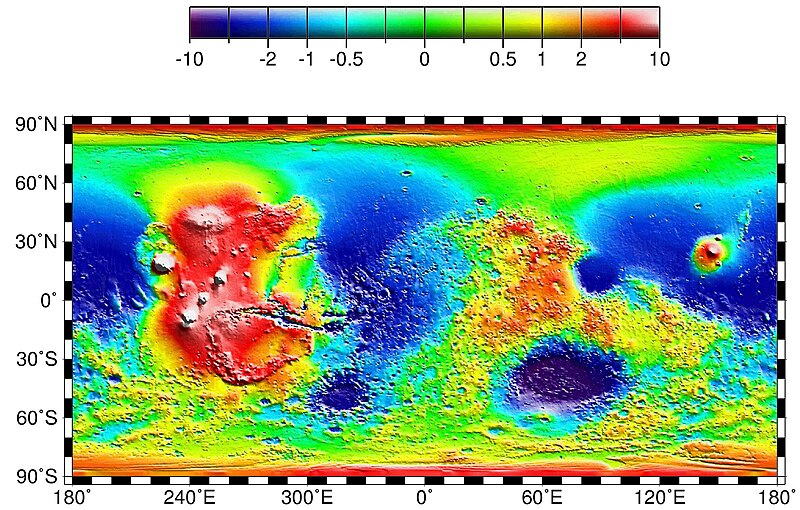
English: Map of Mars' topography with zonal spherical harmonic degree 1 (COM/COF offset along the polar z-axis) removed. The projection is rectangular to show topography from pole to pole. Note the general similarity in elevation between the northern and southern hemispheres. The figure highlights the two other significant components of martian topography: the Tharsis province and the Hellas impact basin. Here we have not removed shorter-wavelength topographic features, including those comprising the dichotomy boundary scarp. |
| Date | (published) |
| Source | Catalog page · Full-res (JPEG · TIFF) |
| Author | NASA/JPL/GSFC |
This image or video was catalogued by Jet Propulsion Laboratory of the United States National Aeronautics and Space Administration (NASA) under Photo ID: PIA02035. This tag does not indicate the copyright status of the attached work. A normal copyright tag is still required. See Commons:Licensing. Other languages:
|
| This media is a product of the Mars Global Surveyor mission Credit and attribution belongs to the Mars Orbiter Laser Altimeter (MOLA) team, NASA/JPL/GSFC |
Licensing
| This file is in the public domain in the United States because it was solely created by NASA. NASA copyright policy states that "NASA material is not protected by copyright unless noted". (See Template:PD-USGov, NASA copyright policy page or JPL Image Use Policy.) | ||
 |
Warnings:
|
Original upload log
The original description page was here. All following user names refer to en.wikipedia.
| Date/Time | Dimensions | User | Comment |
|---|---|---|---|
| 2011-01-17 14:37 | 2761×1759× (1115263 bytes) | Schaffman | {{Information |Description = MOLA topographic Map of Mars |Source = http://photojournal.jpl.nasa.gov/catalog/PIA02035 |Date = ~~~~~ |Author = NASA/JPL/Goddard Spaceflight Center |Permission = JPL Public Use Policy |o |
File history
Click on a date/time to view the file as it appeared at that time.
| Date/Time | Thumbnail | Dimensions | User | Comment | |
|---|---|---|---|---|---|
| current | 03:08, 7 December 2016 | | 2,761 × 1,759 (1.06 MB) | BD2412 | Transferred from en.wikipedia |
File usage
The following pages on the English Wikipedia use this file (pages on other projects are not listed):
Global file usage
The following other wikis use this file: