
File:Baist's real estate atlas of surveys of Washington, District of Columbia - Plate 13.tif

Size of this JPG preview of this TIF file: 800 × 588 pixels. Other resolutions: 320 × 235 pixels | 640 × 470 pixels | 1,024 × 752 pixels | 1,280 × 940 pixels | 2,560 × 1,881 pixels | 9,175 × 6,740 pixels.
Original file (9,175 × 6,740 pixels, file size: 176.95 MB, MIME type: image/tiff)
| This is a file from the Wikimedia Commons. Information from its description page there is shown below. Commons is a freely licensed media file repository. You can help. |
Summary
| Description |
English: Baist's real estate atlas of surveys of Washington, District of Columbia - Volume II - Plate 13 |
| Date | |
| Source | Baist's real estate atlas of surveys of Washington, District of Columbia : complete in three volumes |
| Author | Philadelphia : George William Baist, 1903. |

|
This image is available from the United States Library of Congress's Prints and Photographs division
under the digital ID 87675190. This tag does not indicate the copyright status of the attached work. A normal copyright tag is still required. See Commons:Licensing.
|
Licensing
This work is in the public domain in the United States because it is a work prepared by an officer or employee of the United States Government as part of that person’s official duties under the terms of Title 17, Chapter 1, Section 105 of the US Code.
Note: This only applies to original works of the Federal Government and not to the work of any individual U.S. state, territory, commonwealth, county, municipality, or any other subdivision. This template also does not apply to postage stamp designs published by the United States Postal Service since 1978. (See § 313.6(C)(1) of Compendium of U.S. Copyright Office Practices). It also does not apply to certain US coins; see The US Mint Terms of Use.
|
 | |
| This file has been identified as being free of known restrictions under copyright law, including all related and neighboring rights. | ||
File history
Click on a date/time to view the file as it appeared at that time.
| Date/Time | Thumbnail | Dimensions | User | Comment | |
|---|---|---|---|---|---|
| current | 12:02, 21 December 2017 | 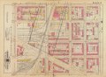 | 9,175 × 6,740 (176.95 MB) | Blazingliberty | User created page with UploadWizard |
File usage
The following pages on the English Wikipedia use this file (pages on other projects are not listed):
Global file usage
The following other wikis use this file:
- Usage on zh.wikipedia.org