Garo Hills Autonomous District Council
This article needs additional citations for verification. (May 2024) |
Garo Hills Autonomous District Council | |
|---|---|
 | |
| Type | |
| Type | |
| Leadership | |
Chief Executive Member | Albinush R Marak[1] |
| Structure | |
| Seats | 30 Councillors (29 elected + 1 nominated) |
 | |
Political groups | Government (17) MDA (17) Opposition (13) Nominated (1)
|
| Elections | |
| 29 plurality voting | |
| 1 nominated | |
Last election | 12 April 2021 |
Next election | 2026 |
| Meeting place | |
| Tura, Meghalaya | |
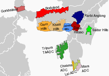
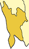
Garo Hills Autonomous District Council (GHADC) is an autonomous district council in the state of Meghalaya in India.[3] It is seated at Tura and covers East Garo Hills district, West Garo Hills district, South Garo Hills district, North Garo Hills district and South West Garo Hills district; is one of the three Autonomous District Councils within Meghalaya, and one of twenty-five autonomous regions of India. The total area of the Garo Hills Autonomous District Council is 10,102 sq km having a population of 1,394,362 as of 2011.
History[edit]
The Constitution of India which was proclaimed in the year 1950 has under Article 244(2) a provision for administration of tribal areas in the then State of Assam as per Sixth Schedule to the Constitution. The States in the North Eastern Region were reconstituted by the North Eastern Areas (Reorganisation) Act 1971 and State of Meghalaya was formed comprising (a) the territories which immediately before that day were comprised in the autonomous State of Meghalaya and (b) so much of the territories comprised within the cantonment and municipality of Shillong, as did not form part of that autonomous State. The table appended to paragraph 20 was divided into three parts. Part II of the table covered the tribal areas of the State of Meghalaya as under:
- United Khasi-Jaintia Hills District
- Jowai District
- Garo Hills District
In 22 October 1976 the Garo Hills district was bifurcated into two districts: West Garo Hills district and East Garo Hills district. The West Garo Hills district was further divided into two districts: West Garo Hills district and South Garo Hills district in June 1992. The South West Garo Hills was carved out of present West Garo Hills and The North Garo Hills district was carved out of the erstwhile East Garo Hills district in 2012.
The Garo Hills Autonomous District Council therefore now comprises the following five districts:
Elections[edit]
Various elections are as follows:
- 2021 Garo Hills Autonomous District Council election
- 2015 Garo Hills Autonomous District Council election
Judiciary Wing[edit]
Paragraph 4 and 5 of the Sixth Schedule provides for administration of justice in Autonomous areas. Under the above paragraphs, the ADCs are empowered to constitute Courts for trials of cases between parties belonging to Scheduled Tribe Communities.


