
Portal:Kent/Sandbox
DesktopMobile
Test of: Transclude files as random slideshow/sandbox
-

-
 An early mention of Kent in the Anglo-Saxon Chronicle between 11th and 12th centuries (from Kent)
 -

-
 Canterbury Cathedral (from Kent)
 -

-
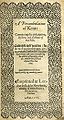 Title page of William Lambarde's Perambulation of Kent (completed in 1570 and published in 1576), a historical description of Kent and the first published county history (from Kent)
 -
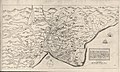 A map of Romney Marsh "The history of imbanking and drayning" by William Dugdale (1662). (from Kent)
 -
 View of the White Cliffs of Dover from France (from Kent)
 -
 The White Cliffs of Dover (from Kent)
 -
 Geological cross-section of Kent, showing how it relates to major towns (from Kent)
 -
 The coat of arms of Kent County Council (from Kent)
 -

-
-

-
 Hand-drawn map of Kent, Sussex, Surrey and Middlesex from 1575. (from Kent)


.jpg)


Apr2006.jpg)


Test of: Transclude linked excerpts as random slideshow/sandbox
-
 Westerham is a town and civil parish in the Sevenoaks District of Kent, England. It is located 3.4 miles east of Oxted and 6 miles west of Sevenoaks, adjacent to the Kent border with both Greater London and Surrey.
It is recorded as early as the 9th century, and was mentioned in the Domesday Book in a Norman form, Oistreham (compare Ouistreham in Normandy, Oistreham in 1086). Hām is Old English for a village or homestead, and so Westerham means a westerly homestead. The River Darent flows through the town, and formerly powered three watermills. (Full article...) -
The Battle of Britain (German: Luftschlacht um England, "air battle for England") was a military campaign of the Second World War, in which the Royal Air Force (RAF) and the Fleet Air Arm (FAA) of the Royal Navy defended the United Kingdom (UK) against large-scale attacks by Nazi Germany's air force, the Luftwaffe. It was the first major military campaign fought entirely by air forces. The British officially recognise the battle's duration as being from 10 July until 31 October 1940, which overlaps the period of large-scale night attacks known as the Blitz, that lasted from 7 September 1940 to 11 May 1941. German historians do not follow this subdivision and regard the battle as a single campaign lasting from July 1940 to May 1941, including the Blitz. (Full article...)
-
Royal Tunbridge Wells is a town in Kent, England, 30 miles (50 kilometres) southeast of central London. It lies close to the border with East Sussex on the northern edge of the High Weald, whose sandstone geology is exemplified by the rock formation High Rocks. The town was a spa in the Restoration and a fashionable resort in the mid-1700s under Beau Nash when the Pantiles, and its chalybeate spring, attracted visitors who wished to take the waters. Though its popularity as a spa town waned with the advent of sea bathing, the town still derives much of its income from tourism. (Full article...)
-
A lathe (/ˈleɪð/; Old English: lǽð; Latin: lestus) formed an administrative country subdivision of the county of Kent, England, from the Anglo-Saxon period, until it fell out of general practical use in the early twentieth century. (Full article...)
-
Deal Castle is an artillery fort constructed by Henry VIII in Deal, Kent, between 1539 and 1540. It formed part of the King's Device programme to protect against invasion from France and the Holy Roman Empire, and defended the strategically important Downs anchorage off the English coast. Comprising a keep with six inner and outer bastions, the moated stone castle covered 0.85 acres (0.34 ha) and had sixty-six firing positions for artillery. It cost the Crown a total of £27,092 to build the three castles of Deal, Sandown and Walmer, which lay adjacent to one another along the coast and were connected by earthwork defences. The original invasion threat passed but, during the Second English Civil War of 1648–49, Deal was seized by pro-Royalist insurgents and was only retaken by Parliamentary forces after several months' fighting. (Full article...)
-
Essex (/ˈɛsɪks/ ESS-iks) is a ceremonial county in the East of England, and one of the home counties. It is bordered by Cambridgeshire and Suffolk to the north, the North Sea to the east, Kent across the Thames Estuary to the south, Greater London to the south-west, and Hertfordshire to the west. The largest settlement is Southend-on-Sea, and the county town is Chelmsford. (Full article...)
-
The Christianisation of Anglo-Saxon England was a process spanning the 7th century. It was essentially the result of the Gregorian mission of 597, which was joined by the efforts of the Hiberno-Scottish mission from the 630s. From the 8th century, the Anglo-Saxon mission was, in turn, instrumental in the conversion of the population of the Frankish Empire. (Full article...)
-
A census of the population of the United Kingdom is taken every ten years. The 2011 census was held in all counties of the UK on 27 March 2011. It was the first UK census which could be completed online via the Internet. The Office for National Statistics (ONS) is responsible for the census in England and Wales, the General Register Office for Scotland (GROS) is responsible for the census in Scotland, and the Northern Ireland Statistics and Research Agency (NISRA) is responsible for the census in Northern Ireland. (Full article...)
-
Essex (/ˈɛsɪks/ ESS-iks) is a ceremonial county in the East of England, and one of the home counties. It is bordered by Cambridgeshire and Suffolk to the north, the North Sea to the east, Kent across the Thames Estuary to the south, Greater London to the south-west, and Hertfordshire to the west. The largest settlement is Southend-on-Sea, and the county town is Chelmsford. (Full article...)
-
Sir Richard Rodney Bennett CBE (29 March 1936 – 24 December 2012) was an English composer of film, TV and concert music, and also a jazz pianist and occasional vocalist. He was based in New York City from 1979 until his death there in 2012. (Full article...)
-
Sevenoaks is a town in Kent with a population of 29,506 situated south-east of London, England. Also classified as a civil parish, Sevenoaks is served by a commuter main line railway into London. Sevenoaks is 21 miles (34 km) from Charing Cross, the traditional centre of London. It is the principal town of the Sevenoaks district, followed by Swanley and Edenbridge. (Full article...)
-
The Darent is a Kentish tributary of the River Thames and takes the waters of the River Cray as a tributary in the tidal portion of the Darent near Crayford. 'Darenth' is frequently found as the spelling of the river's name in older books and maps, Bartholomew's Canals and River of England being one example. Bartholomew's Gazetteer (1954) demonstrates that Darent means "clear water", a result of it springing from and running through chalk. The purity of the water was a major factor in the development of paper and pharmaceuticals in the area. (Full article...)
-
Thomas Becket (/ˈbɛkɪt/), also known as Saint Thomas of Canterbury, Thomas of London and later Thomas à Becket (21 December 1119 or 1120 – 29 December 1170), served as Lord Chancellor from 1155 to 1162, and then notably as Archbishop of Canterbury from 1162 until his death in 1170. He engaged in conflict with Henry II, King of England, over the rights and privileges of the Church and was murdered by followers of the King in Canterbury Cathedral. Soon after his death, he was canonised by Pope Alexander III. He is venerated as a saint and martyr by the Catholic Church and the Anglican Communion. (Full article...)
-
Kent on Saturday (known as the Kentish Saturday Observer until April 2009) is a regional newspaper covering the county of Kent and parts of Southeast London. It is published every Saturday and is part of the KOS Media publishing company. (Full article...)
-
Norman Robert Foster, Baron Foster of Thames Bank, OM, RA, HonFREng (born 1 June 1935) is an English architect and designer. Closely associated with the development of high-tech architecture, Foster is recognised as a key figure in British modernist architecture. His architectural practice Foster + Partners, first founded in 1967 as Foster Associates, is the largest in the United Kingdom, and maintains offices internationally. He is the president of the Norman Foster Foundation, created to 'promote interdisciplinary thinking and research to help new generations of architects, designers and urbanists to anticipate the future'. The foundation, which opened in June 2017, is based in Madrid and operates globally. Foster was awarded the Pritzker Prize in 1999. (Full article...)
-
An oast, oast house or hop kiln is a building designed for kilning (drying) hops as part of the brewing process. They can be found in most hop-growing (and former hop-growing) areas and are often good examples of vernacular architecture. Many redundant oasts have been converted into houses. The names oast and oast house are used interchangeably in Kent and Sussex. In Surrey, Hampshire, Herefordshire and Worcestershire they are called hop kilns. (Full article...)
-
Odo of Bayeux (died 1097) was Bishop of Bayeux in Normandy, and was also made Earl of Kent in England following the Norman Conquest. He was the maternal half-brother of duke, and later king, William the Conqueror, and was, for a time, William's primary administrator in the Kingdom of England, although he was eventually tried for defrauding the William's government. It is likely Odo commissioned the Bayeux Tapestry a large tableau of the Norman Conquest, perhaps to present to his brother William. He later fell out with his brother over Odo's support for military adventures in Italy. William, on his deathbed, freed Odo. Odo died in Palermo Sicily on the way to crusade. (Full article...)
-
Teston /ˈtiːstən/ or /ˈtiːsən/ is a village in the Maidstone District of Kent, England. It is located on the A26 road out of Maidstone, four miles (6.4 km) from the town centre. There is a narrow stone bridge over the River Medway here. (Full article...)
-
The White Cliffs of Dover are the region of English coastline facing the Strait of Dover and France. The cliff face, which reaches a height of 350 feet (110 m), owes its striking appearance to its composition of chalk accented by streaks of black flint, deposited during the Late Cretaceous. The cliffs, on both sides of the town of Dover in Kent, stretch for eight miles (13 km). The White Cliffs of Dover form part of the North Downs. A section of coastline encompassing the cliffs was purchased by the National Trust in 2016. (Full article...)
-
Maidstone is the largest town in Kent, England, of which it is the county town. Maidstone is historically important and lies 32 miles (51 km) east-south-east of London. The River Medway runs through the centre of the town, linking it with Rochester and the Thames Estuary. Historically, the river carried much of the town's trade as the centre of the agricultural county of Kent, which is known as the Garden of England. There is evidence of settlement in the area dating back before the Stone Age. The town, part of the borough of Maidstone, had an approximate population of 100,000 in 2019. Since World War II, the town's economy has shifted from heavy industry towards light industry and services. (Full article...)
-
Aylesford is a village and civil parish on the River Medway in Kent, England, 4 miles (6 km) northwest of Maidstone. (Full article...)
-
A unitary authority is a local authority responsible for all local government functions within its area or performing additional functions that elsewhere are usually performed by a higher level of sub-national government or the national government. (Full article...)
-
Shipbuilding is the construction of ships and other floating vessels. It normally takes place in a specialized facility known as a shipyard. Shipbuilders, also called shipwrights, follow a specialized occupation that traces its roots to before recorded history. (Full article...)
-
Rochester (/ˈrɒtʃɪstər/ ROTCH-iss-tər) is a town in the unitary authority of Medway, in Kent, England. It is at the lowest bridging point of the River Medway, about 30 miles (50 km) from London. The town forms a conurbation with neighbouring towns Chatham, Rainham, Strood and Gillingham. Rochester was a city until losing its status as one in 1998 following the forming of Medway and failing to protect its status as a city. There have been ongoing campaigns to reinstate the city status for Rochester. In 2011 it had a population of 62,982. (Full article...)
