
Portal:Myanmar
ကြိုဆိုပါတယ်။ / Welcome to the Myanmar Portal 

Myanmar, officially the Republic of the Union of Myanmar and also known as Burma (the official name until 1989), is a country in Southeast Asia. It is the largest country by area in Mainland Southeast Asia and has a population of about 55 million. It is bordered by Bangladesh and India to its northwest, China to its northeast, Laos and Thailand to its east and southeast, and the Andaman Sea and the Bay of Bengal to its south and southwest. The country's capital city is Naypyidaw, and its largest city is Yangon (formerly Rangoon).
Myanmar is a member of the East Asia Summit, Non-Aligned Movement, ASEAN, and BIMSTEC, but it is not a member of the Commonwealth of Nations despite once being part of the British Empire. Myanmar is a Dialogue Partner of the Shanghai Cooperation Organization. The country is very rich in natural resources, such as jade, gems, oil, natural gas, teak and other minerals, as well as also endowed with renewable energy, having the highest solar power potential compared to other countries of the Great Mekong Subregion. However, Myanmar has long suffered from instability, factional violence, corruption, poor infrastructure, as well as a long history of colonial exploitation with little regard to human development. In 2013, its GDP (nominal) stood at US$56.7 billion and its GDP (PPP) at US$221.5 billion. The income gap in Myanmar is among the widest in the world, as a large proportion of the economy is controlled by cronies of the military junta. Myanmar is one of the least developed countries; as of 2020, according to the Human Development Index, it ranks 147 out of 189 countries in terms of human development, the lowest in Southeast Asia. Since 2021, more than 600,000 people were displaced across Myanmar due to the surge in violence post-coup, with more than 3 million people in dire need of humanitarian assistance. (Full article...)
Selected articles -
-


Bawbawgyi Pagoda is one of the earliest existing examples of a Burmese pagoda.
Burmese pagodas are stupas that typically house Buddhist relics, including relics associated with Buddha. Pagodas feature prominently in Myanmar's landscape, earning the country the moniker "land of pagodas." According to 2016 statistics compiled by the State Sangha Maha Nayaka Committee, Myanmar is home to 1,479 pagodas exceeding 27 feet (8.2 m) in height, a quarter of which are located in Sagaing Region. Several cities in the country, including Mandalay and Bagan, are known for their abundance of pagodas. Pagodas are the site of seasonal pagoda festivals.
Burmese pagodas are enclosed in a compound known as the aran (အာရာမ်, from Pali ārāma), with gateways called mok (မုခ်, from Pali mukha) at the four cardinal directions. The platform surrounding a Burmese pagoda is called a yinbyin (ရင်ပြင်). (Full article...) -

Mandalay (/ˌmændəˈleɪ/ or /ˈmændəleɪ/; Burmese: မန္တလေး; MLCTS: manta.le: [mándəlé]) is the second-largest city in Myanmar, after Yangon. Located on the east bank of the Irrawaddy River, 631 km (392 miles; road distance) north of Yangon, the city has a population of 1,225,553 (2014 census).
Mandalay was founded in 1857 by King Mindon, replacing Amarapura as the new royal capital of the Konbaung dynasty. It was Burma's final royal capital before the kingdom's annexation by the British Empire in 1885. Under British rule, Mandalay remained commercially and culturally important despite the rise of Yangon, the new capital of British Burma. The city suffered extensive destruction during the Japanese conquest of Burma in the Second World War. In 1948, Mandalay became part of the newly independent Union of Burma. (Full article...) -
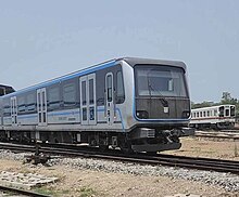
Yangon Circular Railway (Burmese: ရန်ကုန် မြို့ပတ် ရထား [jàɰ̃ɡòʊɰ̃ mjo̰baʔ jətʰá]) is the local commuter rail network that serves the Yangon metropolitan area. Operated by Myanma Railways, the 45.9-kilometre (28.5 mi) 39-station loop system connects satellite towns and suburban areas to the city. Circa 2008–2010, the railway had about 200 coaches, had 20 daily runs, and sold 100,000 to 150,000 tickets daily.
The railway is heavily utilized by lower-income commuters, as it is (along with buses) the cheapest method of transportation in Yangon.
The hours of service have been consistent over the years, from 3:45 am to 10:15 pm daily. In 2011, the cost of a ticket for a distance of 15 miles was two hundred kyats (~eighteen US cents), and that for over 15 miles was four hundred kyats (~37 US cents). In the new currency (introduced in 2012) long distance tickets are 200 kyat (~20 US cents). (Full article...) -

Major General Aung San as Minister of Defence, 1943
The Burma Independence Army (BIA) was a pro-Japanese and revolutionary army that fought for the end of British rule in Burma by assisting the Japanese in their conquest of the country in 1942 during World War II. It was the first post-colonial army in Burmese history. The BIA was formed from a group known as the Thirty Comrades under the auspices of the Imperial Japanese Army after training the Burmese nationalists in 1941. The BIA's attempts at establishing a government during the invasion led to it being dissolved by the Japanese and the smaller Burma Defence Army (BDA) formed in its place. As Japan guided Burma towards nominal independence, the BDA was expanded into the Burma National Army (BNA) of the State of Burma, a puppet state under Ba Maw, in 1943.
After secret contact with the British during 1944, on 27 March 1945, the BNA revolted against the Japanese. The army received recognition as an ally from Supreme Allied Commander, Lord Mountbatten, who needed their assistance against retreating Japanese forces and to ease the strain between the army's leadership and the British. As part of the Anti-Fascist People's Freedom League, the BNA was re-labelled the Patriotic Burmese Forces (PBF) during a joint Allied–Burmese victory parade in Rangoon on 23 June 1945. Following the war, after tense negotiations, it was decided that the PBF would be integrated into a new Burma Army under British control, but many veterans would continue under old leadership in the paramilitary People's Volunteer Organisation (PVO) in the unstable situation of post-war Burma. (Full article...) -
Violent clashes have been ongoing in the northern part of Myanmar's Rakhine State since October 2016. Insurgent attacks by the Arakan Rohingya Salvation Army (ARSA) have led to sectarian violence perpetrated by Myanmar's military and the local Buddhist population against predominantly Muslim Rohingya civilians. The conflict has sparked international outcry and was described as an ethnic cleansing by the United Nations High Commissioner for Human Rights. In August 2017, the situation worsened and hundreds of thousands of refugees fled Myanmar into Bangladesh, with an estimated 500,000 refugees having arrived by 27 September 2017. In January 2019, Arakan Army insurgents raided border police posts in Buthidaung Township, joining the conflict and beginning their military campaign in northern Rakhine State against the Burmese military.
The Muslim Rohingya minority in the region has historically experienced persecution. Laws such as the 1982 Myanmar nationality law ban Rohingya people from obtaining citizenship, and military operations in 1978, 1991 and 1992 against the Rohingya have led to their displacement throughout Rakhine State. Sectarian violence between Buddhist Rakhines and Muslim Rohingyas in 2012 and the 2013 have also caused mass displacements. (Full article...) -
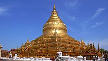
The Shwezigon Pagoda or Shwezigon Paya (ရွှေစည်းခုံဘုရား [ɕwèzíɡòʊɰ̃ pʰəjá]) is a Buddhist stupa located in Nyaung-U, Myanmar. A prototype of Burmese stupas, it consists of a circular gold leaf-gilded stupa surrounded by smaller temples and shrines. Construction of the Shwezigon Pagoda began during the reign of King Anawrahta (r. 1044–1077), the founder of the Pagan Empire, in 1059–1060 and was completed in 1102, during the reign of his son King Kyansittha. Over the centuries the pagoda had been damaged by many earthquakes and other natural calamities, and has been refurbished several times. In recent renovations it has been covered by more than 30,000 copper plates. However, the lowest level terraces have remained as they were.
This pagoda, a sacred Buddhist religious place, is believed to enshrine a bone and tooth of Gautama Buddha. The pagoda is in the form of a cone formed by five square terraces with a central solid core. There are footprints below the four standing Buddha statues here. Jataka legends are depicted on glazed terra-cotta tiles set into three rectangular terraces. At the entrance of the pagoda there are large statues of guardians of the temple. There are also four bronze standing statues of Buddha which are stated to be of the current age Buddha. At the outer limits of the pagoda there are 37 nats deified along with an intricately carved wooden sculpture of Thagyamin, the Burmese version of the Indian god Indra. Within the compound of the Shwezigon Pagoda there is a stone pillar containing Mon language inscriptions dedicated by Kyansittha. (Full article...) -
The Kuomintang in Burma or Kuomintang in the Golden Triangle were Kuomintang (Chinese Nationalist) troops that fled from China to Burma in 1950 after their defeat by the Chinese communists in the Chinese Civil War. They were commanded by General Li Mi. It attempted several incursions into Yunnan in the early 1950s, only to be pushed back into Burma each time by the Chinese Communist Party's People's Liberation Army.
The entire campaign, with logistical support from the Republic of China which had retreated to Taiwan, the United States, and Thailand, was controversial from the start, as it weakened Burmese sovereignty and introduced the KMT's involvement in the region's lucrative opium trade. In 1953, the frustrated Burmese government appealed to the United Nations and put international pressure on the Republic of China to withdraw its troops to Taiwan the following year. As a result, the United States initiated a Four-Nation Military Commission (Burma, the United States, the Republic of China, and Thailand) to negotiate the KMT withdrawal. On 30 May 1954, General Li Mi announced the dissolution of the Yunnan Province Anticommunist National Salvation Army. However, 6,000 irregular KMT troops remained in Burma. Fighting continued sporadically from the irregular troops until coordinated military operations from 1960 to 1961 between the PRC and Burmese governments expelled the remaining irregular KMT troops from Burma. Though most were evacuated to Taiwan, some remained in Burma or formed communities in Thailand. (Full article...) -

Laphet, served in a traditional lacquer tray called laphet ok.
Burmese cuisine encompasses the diverse regional culinary traditions of Myanmar, which have developed through longstanding agricultural practices, centuries of sociopolitical and economic change, and cross-cultural contact and trade with neighboring countries at the confluence of South Asia, Southeast Asia, and East Asia, including the modern-day nations of India, China, and Thailand. Mohinga, a savory fish soup with lemongrass and banana leaves are eaten for breakfast with rice noodles, lunch is rice accompanied with small side dishes of vegetables, a small soup and a meat or fish dish. Dinner is consumed in a similar fashion to lunch. Burmese stews or curries are not Indian curries but milder with reliance on the trio of onion garlic and ginger to create savory gravies. Burmese food does not rely heavily on coconut such as in Thai cuisine. Burmese however enjoy spicy food with addition of chilis mixed into the dishes.
Burmese cuisine is typified by a wide-ranging array of dishes, including traditional stews Burmese curries, Burmese salads, accompanied by soups and a medley of vegetables that are traditionally eaten with white rice. Burmese cuisine also features Indian breads as well as noodles in many forms, such as fried, in soups, or as most popularly consumed as salads. Street food and snack culture has also nurtured the profuse variety of traditional Burmese fritters and modern savory and sweet snacks labeled under the umbrella of mont. (Full article...) -
Atula Thiri Maha Yaza Dewi (Burmese: အတုလသီရိ မဟာရာဇ ဒေဝီ [ʔətṵla̰ θìɹḭ məhà jàza̰ dèwì]; Pali: Atulasīrimahārājadevī; c. 1518–1568) was the chief queen consort of King Bayinnaung of Burma (Myanmar) from 1550 to 1568. The queen was of Toungoo royalty, daughter of King Mingyi Nyo and younger half-sister of King Tabinshwehti. She was the mother of King Nanda. Her 1534 marriage to Bayinnaung, a commoner, solidified an unfailing alliance between Tabinshwehti and Bayinnaung who together would go on to found the Toungoo Empire (or the Second Burmese Empire). (Full article...)
-

The Provisional Government of the Republic of the Union of Myanmar (Burmese: ပြည်ထောင်စုသမ္မတမြန်မာနိုင်ငံတော် အိမ်စောင့်အစိုးရ), is the executive body of Myanmar under the current military junta, the State Administration Council. On 1 August 2021, it replaced the Management Committee of the State Administration Council, which had been in place since 19 February 2021, following the 2021 Myanmar coup d'état. Some ministers were appointed by Min Aung Hlaing immediately following the coup on 1 February, in his capacity as Commander-in-Chief of Defence Services exercising emergency powers.
Due to the state of emergency, the cabinet is led by Prime Minister Min Aung Hlaing rather than Acting President Myint Swe, despite the president being the constitutional head of government. (Full article...)


.JPG)

Did you know (auto-generated) -

- ... that squatters in Myanmar were punished for protesting against the 2021 coup d'état by being evicted?
- ... that the Burmese Buddhist monk Sagyo Thu-Myat successfully lobbied for the recalibration of the Burmese calendar?
- ... that Maw Htun Aung, a Shan Nationalities League for Democracy candidate in the 2020 Myanmar general election, is Kachin, not Shan?
- ... that former Burmese actress Honey Nway Oo turned rebel and took up arms against the military junta following the 2021 Myanmar coup d'état?
- ... that Rangoon kept its own time for more than two decades after Burma Standard Time first came into effect?
- ... that the Burmese and South Korean first ladies held their first informal conversation 44 years after the establishment of bilateral relations between the two countries?
- ... that as part of the coronation of Mindon Min, the square yuzana around the capital was designated a sanctuary?
- ... that Maung O, Prince of Salin, and his sister Nanmadaw Me Nu became de facto rulers of Burma when King Bagyidaw was suffering from depression?
Related portals and projects
General images -
-
 Hlei pyaingbwè - a Burmese regatta (from Culture of Myanmar)
 -
 Saint Mary's Cathedral in Downtown Yangon is the largest Roman Catholic cathedral in Burma. (from Culture of Myanmar)
 -
 A theatrical performance of the Mon dance (from Culture of Myanmar)
 -

-
 Vegetable stall on the roadside at the Madras Lancer Lines, Mandalay, January 1886. Photographer: Hooper, Willoughby Wallace (1837–1912). (from History of Myanmar)
 -
 The paddle steamer Ramapoora (right) of the British India Steam Navigation Company on the Rangoon river having just arrived from Moulmein. 1895. Photographers: Watts and Skeen (from History of Myanmar)
 -
 19th-century funeral cart and spire, which would form part of the procession from the home to the place of cremation (from Culture of Myanmar)
 -
 Myinhkin thabin - equestrian sport (from Culture of Myanmar)
 -
 Pagan Kingdom during Narapatisithu's reign. Burmese chronicles also claim Kengtung and Chiang Mai. Core areas shown in darker yellow. Peripheral areas in light yellow. Pagan incorporated key ports of Lower Burma into its core administration by the 13th century. (from History of Myanmar)
 -
 Temples at Mrauk U, was the capital of the Mrauk U Kingdom, which ruled over what is now Rakhine State. (from History of Myanmar)
 -
 A group of Buddhist worshipers at Shwedagon Pagoda, an important religious site for Burmese Buddhists (from Culture of Myanmar)
 -

-
 A wide range of Burmese lacquerware from Bagan (from Culture of Myanmar)
 -
 Political Map of Burma (Myanmar) c. 1450 CE. (from History of Myanmar)
 -

-
 The shores of Irrawaddy River at Nyaung-U, Bagan (from Geography of Myanmar)
 -
 Salween river at Mae Sam Laep on the Thai-Myanmar border (from Geography of Myanmar)
 -
 Two female musicians play the saung at a performance in Mandalay. (from Culture of Myanmar)
 -
 Aung San Suu Kyi addresses crowds at the NLD headquarters shortly after her release. (from History of Myanmar)
 -
 Recorder's Court on Sule Pagoda Road, with the Sule Pagoda at the far end, Rangoon, 1868. Photographer: J. Jackson. (from History of Myanmar)
 -
 Mountains near Pindaya on the Shan Plateau (from Geography of Myanmar)
 -
 A large fracture on the Mingun Pahtodawgyi caused by the 1839 Ava earthquake. (from Geography of Myanmar)
 -

-
 Myanmar (Burma) map of Köppen climate classification (from Geography of Myanmar)
 -
 Grandfather Island, Dawei (from Geography of Myanmar)
 -
 Protesters in Yangon carrying signs reading "Free Daw Aung San Suu Kyi" on 8 February 2021. (from History of Myanmar)
 -
 Protesters in Yangon with a banner that reads non-violence: national movement in Burmese, in the background is Shwedagon Pagoda. (from History of Myanmar)
 -
 Jade Mine in Hpakant (from Geography of Myanmar)
 -
 Sculpture of Myanmar mythical lion (from Culture of Myanmar)
 -
 Former US President Barack Obama poses barefoot on the grounds of Shwedagon Pagoda, one of Myanmar's major Buddhist pilgrimage sites. (from Culture of Myanmar)
 -
 The restored Taungoo or Nyaungyan dynasty c. 1650 CE. (from History of Myanmar)
 -
 A wedding procession, with the groom and bride dressed in traditional Burmese wedding clothes, reminiscent of royal attire (from Culture of Myanmar)
 -
 Mount Popa, a dormant volcano in the Central Lowlands (from Geography of Myanmar)
 -
 Boxing match, 19th-century watercolour (from Culture of Myanmar)
 -
 British soldiers remove their shoes at the entrance of Shwedagon Pagoda. To the left, a sign reads "Foot wearing is strictly prohibited" in Burmese, English, Tamil, and Urdu. (from Culture of Myanmar)
 -
 A bull fight, 19th-century watercolour (from Culture of Myanmar)
 -
 Aerial view of a burned Rohingya village in Rakhine state, Myanmar, September 2017 (from History of Myanmar)
 -
 Portuguese ruler and soldiers mounting an Elephant. Philips, Jan Caspar (draughtsman and engraver) (from History of Myanmar)
 -
 British soldiers dismantling cannons belonging to King Thibaw's forces, Third Anglo-Burmese War, Ava, 27 November 1885. Photographer: Hooper, Willoughby Wallace (1837–1912). (from History of Myanmar)
 -
 British soldiers on patrol in the ruins of the Burmese town of Bahe during the advance on Mandalay, January 1945. (from History of Myanmar)


_headquarter.jpg)


Major topics
Categories

More topics

Associated Wikimedia
The following Wikimedia Foundation sister projects provide more on this subject:
-
 Commons
Free media repository -
 Wikibooks
Free textbooks and manuals -
 Wikidata
Free knowledge base -
 Wikinews
Free-content news -
 Wikiquote
Collection of quotations -
 Wikisource
Free-content library -
 Wikiversity
Free learning tools -
 Wikivoyage
Free travel guide -
 Wiktionary
Dictionary and thesaurus


